
Dress
Brazilians, even in the major cities, dress casually outside the office. None of the country’s top restaurants insist on collar and tie although the occasional private club does. Collar and tie still predominate in formal office and business surroundings in São Paulo and Rio de Janeiro and most workingwomen wear dresses or skirts. Ladies should remember to pack a jacket or shawl when coming to Brazil, as some of the buildings and restaurants can be a little enthusiastic with the air conditioning. When packing keep in mind that cities like Rio and São Paulo are big, fashionable, cosmopolitan cities and not small tourist resorts. If you forget to bring some item of clothing, don’t worry; you will be able to find what you forgot in any of the big shopping centers. When heading further south in South America, remember to pack some warmer clothes, especially during the Southern Hemisphere’s winter months.
For more information about the weather in Porto Alegre and Canela/Gramado, see http://weather.cnn.com/weather/forecast.jsp?locCode=SBPA
Temperature in Canela and Gramado is normally about 5 Celsius degrees less than Porto Alegre.
Drugs
Brazil, like most South American countries, takes a dim view of drug offences, including by foreign visitors. Your own consulate is likely to agree.
Money and Exchange Rates
Brazil’s currency since 1 July, 1994, is the Real (R$) which is roughly valued at R$3.00 = US$ 1.00 Most Brazilians understand dollars and as a foreign currency it is by far the most widely accepted and throughout the country gives the best exchange rate. In the main cities there is little problem in changing other foreign currencies and there is an extensive network of ATMs. Most major credit cards are accepted in Brazil. As when visiting any country, it is worth getting hold of some low denomination notes and coins on arrival.
Serra Gaúcha
North of Porto Alegre, you quickly begin to climb into the Serra Gaúcha. The ride is beautiful, as are the mountain towns of Gramado and Canela, 140 km from Porto Alegre. First settled by Germans (in 1824) and later by Italians (in the 1870s), the region is as close to the Alps as Brazil gets. It’s known as the Região das Hortênsias (Hydrangea Region). Both Gramado and Canela are popular resorts and are crowded with Porto Alegrenses in all seasons, but particularly when it’s hottest in the big city. There are plenty of hotels and restaurants, especially in Gramado (8 km from Canela), and many have a German influence. Hikers abound in the mountains here. In winter there are occasional snowfalls and in spring the hills are blanketed with flowers. The best spot is the Parque Estadual do Caracol, reached by local bus from Canela, eight km away.
Canela
“If you’re scared of leopards, hate mosquitoes, but want to do some ecological tourism, come to Canela.” (Canela tourist brochure)
CANELA , 8km east of Gramado, down a road bordered on both sides by hydrangeas, is slightly lower, smaller and less commercialized, but otherwise, it’s much like its neighbour. Canela offers little of particular beauty within its small urban area, but it is better situated for the Parque Estadual do Caracol (daily 8.30am-5.30pm), 8km to the north. You can reach the park by bus – marked “Caracol Circular” (4 daily) – which leaves from next to the old steam engine in the centre of Canela; get off at the restaurant-tourist complex in the park. From here, a path leads down to the foot of a waterfall, the park’s main attraction, and other paths lead to different small falls at higher levels, from where there are panoramic views into the deep canyon of the Rio Caí. There’s also a good campsite in the park.
While not as up-market as Gramado, Canela is the best jumping-off point for some great hikes and bicycle rides in the area. There are cheaper hotels here than in Gramado, so budget travelers should make this their base.
Parque Estadual do Caracol
Eight km from Canela, the major attraction of this park is a spectacular 130-meter-high waterfall. You don’t have to do any hiking to see it, as it’s very close to the park entrance. On the road to the park, two km from the center of Canela is a 700-year-old, 42-meter-tall araucária pine. The park is open daily from 7:30 am to 6 pm.
Ferradura
A seven-km hike from just outside the park entrance brings you to Ferradura, a stunning 400-meter-deep horseshoe canyon formed by the Rio Santa Cruz. You can camp in here, but you have to bring everything with you.
Parque das Sequóias
This park at Rua Godofredo Raimundo 1747 was created in the 1940s by Curt Menz, a botanist who cultivated more than 70 different tree species with seeds from all over the world. This plantation occupies 10 hectares, and the rest of the park (25 hectares) is native forest. The park has lots of trails and a pousada.
Morros Pelado, Queimado & Dedão
These hills provide great views of the Vale do Quilombo, and on clear days you can see the coast. Reached via the road to the Parque das Sequóias, they’re five, 5.5 and 6.5 km (respectively) from Canela.
Castelinho
One of the oldest houses in the area, Castelinho, is on the road to the park. Now a pioneer museum, a German restaurant and a chocolate shop, Castelinho was built without using metal nails. Festival From 26 to 28 May, 80,000 pilgrims arrive in Canela to celebrate the Festa de Nossa Senhora de Caravaggio. A highlight of the festival is a six-km procession from the Igreja Matriz to the Parque do Saiqui.
Parque nacional de Aparados da Serra
One of Brazil’s natural wonders, the National Park located 100 km distant from Canela, consisting of an escarpment with deep V-shaped valleys cutting through it. The area is one of the main centres of Eco-tourism in the south of Brasil and has been attracting both the hard core adventurer looking for a challenge and the nature lover seeking a peaceful place and beautiful views. It is 70 km north of São Francisco de Paula and 18 km from the town of Cambará do Sul.

Things to See
The park preserves one of the country’s last araucária forests, but the main attraction is the Canyon do Itaimbézinho, a fantastic narrow canyon with sheer 600 to 720-meter parallel escarpments. Two waterfalls drop into this deep incision in the earth, which was formed by the Rio Perdiz’s rush to the sea.

Another of the park’s attractions is the Canyon da Fortaleza, a 30-km stretch of escarpment with 900-meter drops. You can see the coast from here. Nearby, on one of the walls of the canyon, is the Pedra do Segredo, a five-meter monolith with a very small base. It’s 23 km from Cambará, but unfortunately in a different direction from Itaimbézinho.
Vale dos Vinhedos – Bento Gonçalves
Bento Gonçalves was founded with strong tradition in grape culture and the production of wine and it is situated among valleys covered of vines and it is the second largest wine producting area of Brazil and the main producer of fine wines, for which it received the title of “The Capital of the Wine.”
Vale dos Vinhedos (Vineyards Valley) – it is a valley among Bento Gonçalves, Garibaldi and Monte Belo do Sul boarders. Wines from Vale dos Vinhedos is globally known. The techniques guarantee the product quality, which already earned important national and international prizes, mainly in countries of Europe. In the summer the main attraction is to eat the grapes in the vineyards, to accompany the winegrowers’ work, to see how the wine and juice are produced.

Rafting – Três Coroas
Experience a three hour or one day adrenaline rush, going down the wild rapids of the Paranhana- or Caí River. These rivers trip are a 3 Km or 15 km of adventure and fun. The rapids range from level 3 to 4. It is a great family tour. Transportation from Canela, 1/2 hour drive (15 km).


Rio Grande do Sul state Road Map Rio Grande do Sul State map – PDF document – 2.600Kb
Rio Grande do Sul State map – ZIP compressed – 2.200Kb
To open PDF files download the Acrobat Reader.
Canela na sua Região
Região das Hortênsias, Planalto das Araucárias, Rota Romântica e Serra Gaúcha são alguns dos principais roteiros turísticos da América do Sul. Em todos, Canela ocupa uma posição de destaque. Aqui você também está próximo dos Canyons dos Aparados da Serra, do Roteiro da Uva e do Vinho, dos Campos de Cima da Serra e da Grande Porto Alegre. 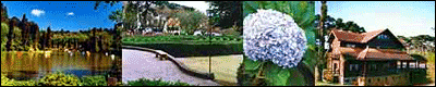
Canela se destaca na região como um grande pólo turístico ligado à natureza, ao ecoturismo e também ao turismo de aventura. Outro destaque da cidade são seus grandes eventos culturais.
Região das Hortências
Canela está localizada no centro da Região das Hortênsias, formada também pelos municípios de Gramado, Nova Petrópolis e São Francisco de Paula. A colonização alemã desta região é destacada pela cidade de Nova Petrópolis, com casas de jardins floridos que demonstra o perfeccionismo dos seus habitantes, você se sentirá na Alemanha. Em Nova Petrópolis você deve conhecer a Aldeia do Imigrante e o Labirinto na praça central. A 7 km de Canela, está Gramado misturando a colonização alemã com a italiana, possuindo um destacado centro comercial, e sua arquitetura típica. Conheça em Gramado o Palácio dos Festivais, onde se realiza o Festival de Cinema de Gramado, e também o Lago Negro. A 32 km de Canela está São Francisco de Paula, com grade destaque pela manutenção dos hábitos do Gaúcho, e pela formação natural saindo da Mata de Araucária, em Canela e chegando aos Campos de Cima da Serra.
Aparados da Serra
Após São Francisco de Paula, se chega a Cambará do Sul, a cidade dos canyons. Na divisa com Santa Catarina, você encontra uma série de canyons, sendo os mais conhecidos o Itaimbézinho e o Fortaleza. A região é conhecida por Aparados da Serra, onde estão os parques nacionais dos Aparados da Serra e da Serra Geral. Esta cidade está somente a 100 km de Canela.
Rota Romântica
Canela também faz parte da Rota Romântica, roteiro turístico que mostra o berço da colonização alemã no estado. Partindo de São Leopoldo na Grande Porto Alegre, passando pelo pólo calçadista e por cidades bucólicas de colonização alemã, chegando a Região das Hortênsias. Fazem parte deste roteiro 13 municípios.
Uva e Vinho
Canela também está a aproximadamente 90 km da Região da Uva e do Vinho, como é conhecida a região de colonização italiana, onde se destaca a cidade de Bento Gonçalves pela sua produção de vinhos e Caxias do Sul pelo seu pólo industrial. Além destas cidades compõem a região uma série de pequenas cidades com destaque para os produtos agrícolas e artesanais. Como você pode ver Canela está no centro, de um raio de aproximadamente 100 km, dos maiores atrativos turísticos do Rio Grande do Sul. Você pode verificar as diferenças étnicas com suas respectivas culturas, e também apreciar as mais belas paisagens naturais da região.
Situação Geográfica
Canela localiza-se na micro-região 309 (RS), nos degraus da encosta inferior do nordeste e na extremidade sul da Serra Geral. O município é dividido pelo Rio Caí (Santa Cruz), abrangendo as nascentes do Rio Paranhana (Santa Maria).
Limites
Leste: São Francisco de Paula
Norte: Caxias do Sul
Sul: Três Coroas
Oeste: Gramado
LATITUDE: 29º 20′ 15″ S
LONGITUDE: 50º 53′ 00″ O
Altitude
A altitude oficial de Canela é de 830m acima do nível do mar, na praça João Corrêa. O ponto mais alto localiza-se no loteamento Vila do Cedro, com 882m e, na localidade denominada Passo do Loro, o mais baixo, com 80m.
Área
O município possui uma área de 270 km2, sendo 20Km2 a área urbana (7,4%), e 250 km2, a área rural (92,6%).
Clima
A temperatura no verão é de aproximadamente 21,5ºC e, no inverno, de aproximadamente 7,6ºC, o que resulta na média global de 14,5º C. A temperatura máxima registrada é de 35,8º C e a mínima -2,7º C.
População
Atualmente o município de Canela conta com cerca de 30 mil habitantes, sendo formada por alemães (30%), italianos (30%), portugueses (30%) e outros (10%).
Distâncias
Gramado 7 km
São Francisco de Paula – 35 km
Nova Petrópolis – 38 km
Caxias do Sul – 84 km
Cambará do Sul – 98 km
Bento Gonçalves – 118 km
Porto Alegre – 130 km
Florianópolis – 575 km
Curitiba – 860 km
Montevidéu – 868 km
São Paulo – 1265 km
Buenos Aires – 1430 km
Rio de Janeiro – 1654 km
Brasília – DF – 2210 km